If you've travelled anywhere in Ohio you've likely noticed its expansive flat land and occasional rolling hills. While this holds true for much of the state, its southeastern reaches are quite different. This area, often referred to as Ohio's Hill Country, is part of one of the world's oldest mountain ranges, the Appalachians. And, within Ohio's Hill Country you'll find the Hocking Hills Region, the state's crown jewel. Here, dense hemlock forests, large rock formations, towering cliffs, massive recessed caves, and beautiful waterfalls dot the landscape providing an outdoor playground like nowhere else in the state. Several miles of the blue blazed Buckeye Trail, the longest circular trail in the nation at more than 1,400 miles long, wind through the region's hills, hollows, and gorges. The most beautiful of all of those miles can be found in Hocking Hills State Park where the trail cuts through the heart of the park, rising and falling throughout its Blackhand sandstone gorge, passing beside picturesque waterfalls and fascinating geologic features. On this trip we explored several of the region's most beautiful hiking trails, rock climbed sandstone cliffs, relaxed while viewing the night sky in its near pristine state, and more.
Day 1
Upper & Lower Falls, Devil's Bathtub, Old Man's Cave & Broken Rock Falls (1.6 miles/200')
Ash Cave to Ash Cave Fire Tower (2.8 miles/300')
John Glenn Astronomy Park
We started our trip with what is widely regarded as the most stunning hike in the Hocking Hills region, particularly within Hocking Hills State Park. We accessed the Buckeye Trail from the far-left (northeast) corner of the Old Man's Cave parking area. After a short walk, we encountered a stone footbridge leading to the trail's first waterfall, Upper Falls. Encircled by sandstone cliffs, Upper Falls drops 20 feet along Old Man's Creek, offering superb photo opportunities from both above and below.

Continuing along the Buckeye Trail at the Gorge Overlook Trail junction, we were next met with a second stone footbridge at Devil's Bathtub. This bowl-shaped basin creates a whirlpool along a distinctive section of the streambed. Despite rumors suggesting it reaches the depths of hell, the Devil's Bathtub is actually only a few feet deep.

We continued to follow the blue blazes for approximately another half mile, traversing five additional bridges before arriving at the marked stairs leading to Old Man's Cave. We ascended the stairs to access the cave, measuring 250 feet wide by 50 feet high, which boasts some intriguing historical significance.

The name Old Man's Cave originates from the hermit who once dwelled in the large recessed cave within the gorge. Legend tells the story of Richard Rowe, a Tennessee Cumberland Mountains native, who arrived in the area around 1796 to establish a trading post. During the trapping season, he frequently visited the gorge and made the cave his temporary home. According to the tale, while stopping at a stream for water, he accidentally fired his rifle, hitting himself under the chin and succumbing to the injury. Trappers discovered his body days later and gave him a burial somewhere near the cave, though the exact location remains unknown. Today, it stands as one of the most popular attractions in Hocking Hills State Park.
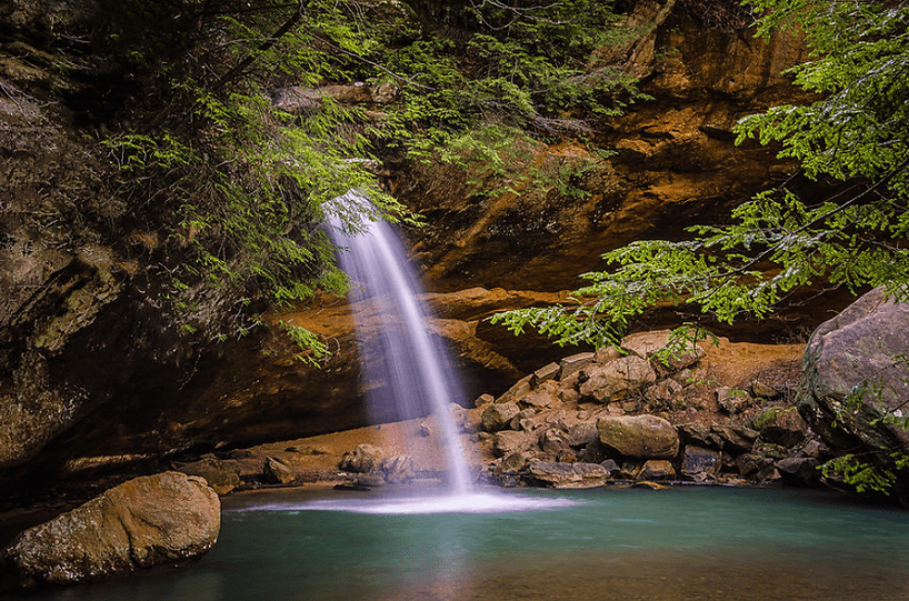
After exploring Old Man's Cave, we retraced our steps back to the bottom and continued our hike along the Buckeye Trail. We continued for another tenth of a mile or so until reaching another stone footbridge and the remarkably scenic Lower Falls. This 25-foot waterfall cascades over a sandstone cliff into an emerald plunge pool surrounded by a sandy shore, making it, in our opinion, the park's finest area.

We followed the stone staircase on the left side of the falls, which led to the Broken Rock Falls Trail junction. Here, we turned left and followed the trail for about a tenth of a mile to reach Broken Rock Falls, one of the more distinctive waterfalls in the state. Its name is derived from the way it seems to slice through the sandstone cliff from which it descends. This waterfall also attracts fewer visitors compared to most others in the area, offering a chance to enjoy its beauty in solitude, even if only for a brief period.

After we finished exploring Broken Rock Falls, we returned to the trail junction and ascended a stone staircase leading to an area above Old Man's Cave, and eventually back to the parking area.
After the hike, we took a ten-minute drive to the park's southern boundary and reached the trailhead for Ash Cave. The impeccably maintained trail leads to a magnificent 85-foot waterfall cascading over the top of the cave from a Queer Creek tributary. When European settlers discovered the cave, they found large piles of ash inside, one of which was three feet deep, one hundred feet long, and thirty feet wide. Archaeological evidence suggests that these ash piles originated from campfires left by Native Americans, particularly the Shawnee. Subsequently, European settlers used the cave as a church until an actual building could be constructed to accommodate the congregation.

Later in the evening, once the sun had bid its farewell, we made our way to the John Glenn Astronomy Park. On a clear night, it's a challenge to find a darker sky in Ohio for stargazing. The park hosts guided stargazing programs on Friday and Saturday nights from March through November, and it's essential to make a reservation to attend. This is a must-visit, especially if a meteor shower is anticipated.
Day 2
High Rocks Adventures & Hocking Hills Canopy Tours
Robinson Falls Boch Hollow (0.5 miles/100')
Rock House (1.1 miles/200')
Conkle's Hollow Gorge & Rim (3.8 miles/500')
We began our second day with a guided rock climbing tour at High Rock Adventures, situated twenty minutes north of Hocking Hills State Park, adjacent to Clear Creek Metro Park. Led by experienced climbing guides, we ascended sandstone cliffs ranging from 30' to as high as 90'. This immersive experience comes highly recommended and caters to all skill levels, with climbing gear provided.
Another twenty minutes north of Hocking Hills State Park lies Boch Hollow State Nature Preserve, a lesser-visited park harboring one of the state's best-hidden gems—Robinson Falls. Accessing the preserve requires a free permit, which we obtained through the Ohio Department of Natural Resources website. To reach the falls' trailhead, we drove to the corner of Zwickle Rd and Rt-664, where a small parking area is located on the west side of Rt-664. The unsigned trailhead to Robinson Falls is on the opposite side of the road from the parking area. Following a brief descent to the streambed, we traced the creek upstream until reaching the falls, less than a quarter mile later. While smaller in size compared to those from the previous day, Robinson Falls is undeniably beautiful. A deep plunge pool is situated near the falls, but note that swimming is prohibited in the preserve, similar to the falls in Hocking Hills State Park.

After Robinson Falls, we headed back south to explore one of the region's renowned geological wonders—Rock House. Officially designated as the only cave by definition in the park, Rock House is a 200-foot-long tunnel-like passageway featuring seven natural windows facing south. Local legend has it that the cave served as a hideout for robbers, murderers, and bootleggers in the nineteenth century, earning it the moniker "Robber's Roost." Archaeological findings suggest that the cave was previously inhabited by Native Americans, likely the Shawnee, who utilized the small wall recesses within the cave as baking ovens.

As our day wound down, we headed to the nearby Conkle's Hollow State Nature Preserve, where two stunning hiking trails awaited us. The Gorge Trail, a well-maintained and mostly paved path, meanders through the heart of the gorge, culminating in a beautiful seasonal 20-foot waterfall. The entire hike to the falls was breathtaking, often cited by locals as their favorite hike in the area. Walking through the gorge, we were immersed in masses of ferns, hemlock, and birch. The vegetation is so dense in certain areas that sunlight struggled to reach the valley floor. Towering above were the gorge's 200-foot-high vertical cliffs, gradually narrowing the deeper we ventured into the gorge.

The second and longer Rim Trail follows the cliffs' edge for 2.5 miles, encircling the gorge entirely. Much of the trail winds through a dense hemlock forest, occasionally offering cliff-top views on the east rim. We caught sunset from the east time which was one of the highlights of the trip.
Day 3
Cedar Falls & Whispering Cave (2.5 miles/150')
Cantwell Cliffs (1 mile/250')
Saltpetre Cave Nature Preserve
We began our final day with a hike to the picturesque Cedar Falls, renowned as the largest waterfall by volume and the most consistent in the Hocking Hills Region. The 50-foot falls gracefully slides down a substantial sandstone formation, divides in the middle, then reunites before cascading its final ten feet into the emerald pool below.

Afterward, we hiked out to Whispering Cave, an equally impressive but less-visited recessed cave in the area. Just over half a mile north of Cedar Falls, we came across Whispering Falls, a less imposing waterfall to the right of the trail. We continued on the blue-blazed Buckeye Trail for approximately seven-tenths of a mile until we reached an unmarked split in the trail, leading over a small bridge known as the Hemlock Suspension Bridge. We crossed the bridge and ascended a fairly steep section of the trail that leads to a series of large cliffs. At the cliffs, we turned left, and in less than a quarter mile, we arrived at Whispering Cave.
A hidden gem and less-frequented spot in the area is Saltpetre Cave State Nature Preserve, located just ten minutes north of Hocking Hills State Park, near Conkle's Hollow State Nature Preserve. This small 14-acre preserve boasts large recessed sandstone caves, with one reaching up to 148 feet in depth, featuring 8-foot ceilings and a 125-foot opening. Another cave includes a natural arch with an opening of more than 100 feet. In total, there are four caves accessible via an established trail. The area is also home to the state's largest population of hemlocks. A free permit is required for parking and entry, and the application can be found on the Ohio Department of Natural Resources website. Once your permit is approved, you'll receive emailed directions, preserve rules, and a map. Although the ODNR requested not to share the area map due to permit requirements, there's a high likelihood that you'll have the place to yourself. Bring a headlamp or flashlight regardless of the time you embark on the trek.
_edited.png)


Comments